
Roof plan surveys
Accurate existing roof plans showing ridges, valleys, eaves, pitches and levels, captured from the ground with a 3D laser scanner or from the air with a survey drone, and drawn in DWG and PDF.
What a roof plan shows
A roof plan shows the building from directly above with the roof in place. It records every ridge, hip, valley and eaves line with its level, the pitch and fall of each slope, and everything fixed to the roof: chimneys, dormers, rooflights, vents, aerials and rainwater goods. Areas we could not see are marked clearly on the drawing rather than guessed.
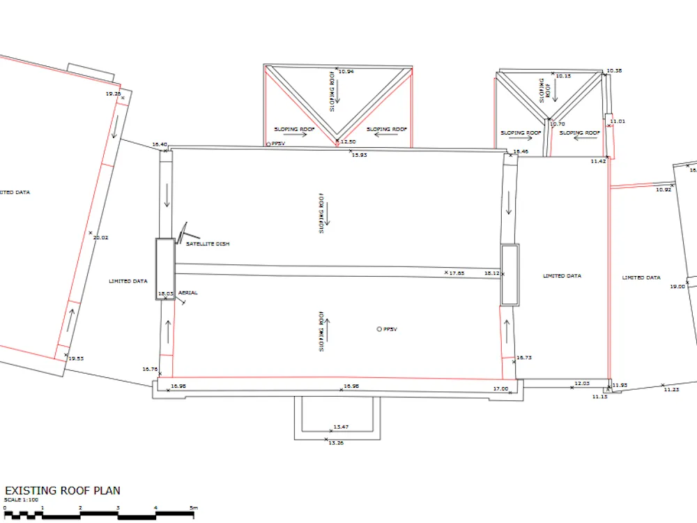
Captured from the ground or the air
We choose the capture method for each roof. Many pitched roofs can be recorded from the street and garden with a 3D laser scanner, which picks up ridges, eaves and chimneys several storeys up. Where slopes, flat roofs or valleys are hidden from below, we fly the roof with a survey drone and merge the data with the ground scan. Either way, there is no scaffolding and nobody on the roof.
For planning and design
Roof plans are most often ordered to support planning applications and design work such as loft conversions, dormers, extensions and roof replacements. They are usually surveyed at the same time as floor plans, elevations and street scene elevations, so the whole existing drawing set comes from one visit.
Drawings you can use straight away
Roof plans are drawn to the scale your project needs and issued as layered DWG and PDF, to our standard or to your office template. If you need more than 2D drawings, the same survey can be turned into a BIM model.
Roof plan or roof inspection?
A roof plan is a measured drawing for design: positions, levels and pitches, drawn to scale in CAD. If you want to know the condition of a roof, such as slipped tiles, flashing defects or a damaged chimney, a drone roof inspection is the better choice, with high-resolution photos and video of every slope. Both can be flown in the same visit if you need them.
How it works
Scope
Agree the roofs to be drawn, the level of detail and any neighbouring roofs you need shown.
Survey
We capture the roof from the ground with a 3D laser scanner, or fly it with a survey drone where slopes and flat roofs cannot be seen from below.
Draft and check
The roof plan is drafted from the point cloud, with levels on ridges, eaves and key points, and checked before issue.
Who we work with
Architects
Existing roof plans for loft conversions, extensions and planning drawings.
Designers and engineers
Levels, pitches and drainage for roof design and structural checks.
Planning applicants
An accurate existing roof plan to sit alongside proposed drawings.
Where we work
From our base in Leigh-on-Sea, Essex, we carry out roof plans across London, Essex, Kent, Hertfordshire and the rest of the UK. Local pages:
What clients say
Read our reviews on Google★★★★★
Having worked with THS for several years now, each project is treated with high professionalism every time. We would highly recommend their team.
★★★★★
I was impressed by THS Concepts topographical survey services' professionalism and accuracy. They were efficient and reasonably priced. I highly recommend them.
★★★★★
We recently approached THS Concepts to carry out a level survey of the screed to the ground floor of a large residential property we were Project Managing. The property was undergoing extensions and refurbishment work. We had a tight timescale to receive the information, and THS Concepts delivered quickly and efficiently to meet our deadline. This is the second time we have used them and would highly recommend.
Roof plans: common questions
How do you survey a roof without scaffolding?
Most pitched roofs can be captured from the ground with a 3D laser scanner. Where the roof cannot be seen from below, such as flat roofs, rear slopes and valleys, we fly it with a survey drone and merge the data, so nobody needs to go up.
What scale are roof plans drawn at?
To suit your project, usually 1:100 or 1:50, and supplied as DWG and PDF.
Can you include neighbouring roofs?
Yes. Adjoining roofs can be shown in full or as an outline, which helps planners judge how a proposal fits next door.
Can you produce a 3D or BIM model of the roof?
Yes. Most projects only need a 2D roof plan, but the same survey data can be turned into a BIM model if required.
Guides
Related services
- Drone surveys
Aerial LiDAR, mapping and roof inspections.
- 3D laser scanning
Point clouds and BIM models of buildings, plant and structures.
Tell us about your site
Send a location, a rough brief and your deadline. We reply with a fixed quote within 24 hours.