Limited Time Offer: Enjoy 10% Off All Services
Get a quote now – this discount won’t last long!
Ground Movements and Building Foundations: Your Ultimate Guide to Monitoring Settlement and Heaving.
Article By: Tom Ayre
Last Update: April 2022
In this article, we are going to discuss 3 methods used to monitor a building for heave or settlement.
To clarify, heave is where the ground is pushed upwards and settlement is where the ground lowers. Both heave and settlement can cause serious issues with buildings. The difficulty in monitoring a building for vertical movement is that you have to have precision equipment to do it accurately. Using a tape measure or laser simply won’t work if you are looking for precision.
The three methods described below are industry standard ways of monitoring movement. Let’s begin.
Ground movement heave refers to an upward movement of the ground surface due to the expansion or contraction of soil or other subsurface materials. This movement can be caused by a variety of factors, such as changes in the water content of the soil, the presence of underground voids or cavities, or the settling or shifting of the soil due to changes in weight or pressure
Ground settlement refers to a downward movement of the ground surface due to the compaction or consolidation of soil or other subsurface materials. This movement can be caused by a variety of factors, such as the weight of a building or other structure, the extraction of underground resources, or changes in the water content of the soil.
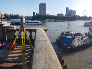
A total station is a surveying instrument that is used to measure angles and distances between points on the ground. It consists of a theodolite (an instrument used to measure angles) mounted on an electronic distance measurement (EDM) device, which uses lasers or infrared beams to measure distances.
Total stations are typically used in a wide range of surveying applications, including topographic surveys, boundary surveys, construction layout, and mapping. They are particularly useful for collecting precise measurements over long distances, and for creating detailed maps of the ground surface.
Total stations are typically operated by a surveyor who sets up the instrument at a known point, known as a “station,” and uses it to measure angles and distances to other points on the ground. The surveyor can then use these measurements to create a map of the area being surveyed, or to calculate the position and elevation of specific points.
Total stations are highly accurate and efficient instruments that are widely used in surveying and mapping applications. They are typically more precise and efficient than traditional surveying methods, such as tape measures or hand levels, and they can be used to collect a large amount of data in a short period of time.
A total station is a very accurate method of obtaining vertical movement on the point it is checking. The total station requires a number of fixed points around the area that aren’t expected to move. These locations are used to each time to set up the device and give an accurate reading of height movement.
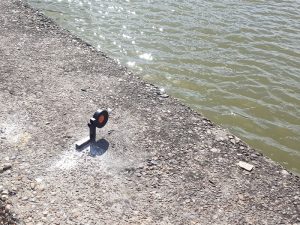
The monitoring targets fixed to a building are usually prisms or reflective targets.
Advantages
Disadvantages
Conclusion
Surveying with a total station to check settlement / heave has been undertaken for a number of years. The methodology is easily repeatable on each visit, making the results very accurate and reliable.
Having a surveyor visit the site each time means data is only shown after each visit. The surveyor also needs a fixed network of points and a solid base to set the total station up on. Without these, accuracy is lost.


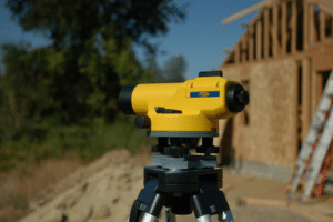
A dumpy level is a type of surveying instrument that is used to measure the elevation of points on the ground. It consists of a telescope mounted on a tripod, which is used to sight points on the ground and determine their elevation relative to a reference point.
Dumpy levels are typically used to measure the elevation of points on the ground in order to create contour maps or to establish the elevations of points for construction projects. They are often used in conjunction with a staff or rod, which is held at the point being surveyed and used to measure the distance from the ground to the telescope.
To use a dumpy level, the surveyor first sets up the instrument at a known point, known as a “benchmark,” and levels the instrument using adjustable screws and bubble vials. The surveyor then sights the point being surveyed through the telescope and uses the horizontal crosshairs to determine the elevation of the point relative to the benchmark.
Overall, dumpy levels are simple, reliable, and accurate instruments that are widely used in surveying and construction applications. They are particularly useful for collecting precise elevations over short distances, and for creating detailed maps of the ground surface.
To monitor the building, a number of fixed monitoring locations need to be established. To make it easy to take the measurements with the measuring staff, these points will need to be offset from the wall, such as a screw / wall plug or fixed level plate. It is on top of these the staff is placed and then the measurement recorded.
Like a total station, a dumpy level requires a set location that is assumed doesn’t move. It is from this point that all measurements are calculated and referenced back to.
Advantages
Disadvantages
Conclusion
A dumpy level is a very accurate way of surveying levels around a building. However, it does require some bulky objects / screws protruding from the building and also fixed positions to reference back to that cannot move.
The dumpy level method does require an on site visit and requires 2 people to undertake the task. A dumpy level is relatively low cost when purchasing other monitoring devices.

A tilt beam sensor is a type of sensor that is used to measure the angle or inclination of an object or surface. It consists of a beam or lever that is mounted on a pivot point and equipped with one or more sensors that measure the angle of the beam relative to a reference point.
Tilt beam sensors are typically used in a variety of applications, including monitoring the inclination of structures, such as bridges or towers, detecting the movement of earth or other objects, and measuring the angle of slopes or other surfaces.
There are several types of tilt beam sensors, including mechanical sensors that use a lever and pivot point to measure the angle of the beam, and electronic sensors that use accelerometers or other sensing devices to measure the angle of the beam.
Tilt beam sensors are typically small, compact, and rugged, and they are able to withstand a wide range of environmental conditions. They are also relatively inexpensive and easy to use, which makes them a popular choice for many applications.
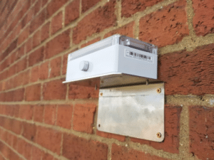
Tilt beam sensors installed in tandem with others can give you a movement profile over the length of a wall. By comparing precise tilt angles, you can gauge the extent and locations that movement is occurring.
The sensors are installed by either attaching them to a continuous beam along the wall or simple screwed using wall plugs / screws.
Advantages
Disadvantages
Conclusion
Tilt beam sensors provide a convenient way of capturing a lot of data without the need to continually visit the site. The biggest disadvantage is that the sensors can only record angular movement, which can sometimes be difficult to interpret in an up / down direction.
Often tilt sensors are installed alongside other movement monitoring techniques and can be used to observe early movement trends due to their precise angular measurements.

92 Bellhouse Lane, Leigh-on-Sea, Southend-On-Sea, Essex, SS9 4PQ
76 Quill Street, Finsbury Park, London, N4 2AD
THS Concepts has a passionate team of surveyors and CAD draughtsman delivering detailed, thorough and accurate surveys and CAD drawings. We are far more than just a land and building surveying company.
Terms & Conditions | XML Sitemap | Copyright 2022 – THS Concepts LTD