Measured Surveys
Precision 3D Scanning and CAD Drawings for Your Buildings
THS Concepts offers in-depth as-built measured building surveys. Our team provides architects and construction professionals with highly accurate and detailed CAD drawings for all their design needs.
- 3D Laser Scanning - Accurate, swift, non-invasive.
- Experienced survey team, 1000's of projects completed.
- Accurate, fast, non-invasive, and complete data capture.
- Save time with our streamlined CAD drawings templates.
- Large and small sites across the United Kingdom.
Need a Quote For Your Project?
In search of immediate pricing? Obtain an instant online estimate or secure a fixed cost for your project. Please use the buttons below.


Full TSA Member
THS Concepts are an accredited member of The Survey Association body.
UK Wide Service
We operate nationwide across London & the United Kingdom.
Years Of Experience
THS Concepts was formed over 10 years ago in 2013.
Fully Insured
£1 million in liability cover, employers' and public liability insurance.
Excellent Service
We take great pride in our exceptional 5-star ratings on both Google and Trustpilot
What We Typically Provide Our Clients With
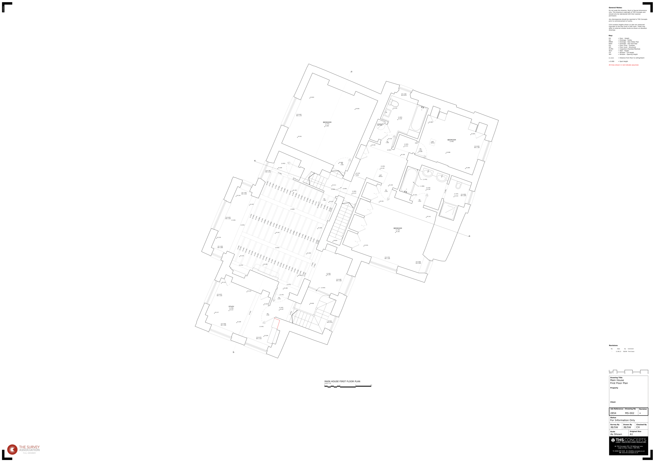
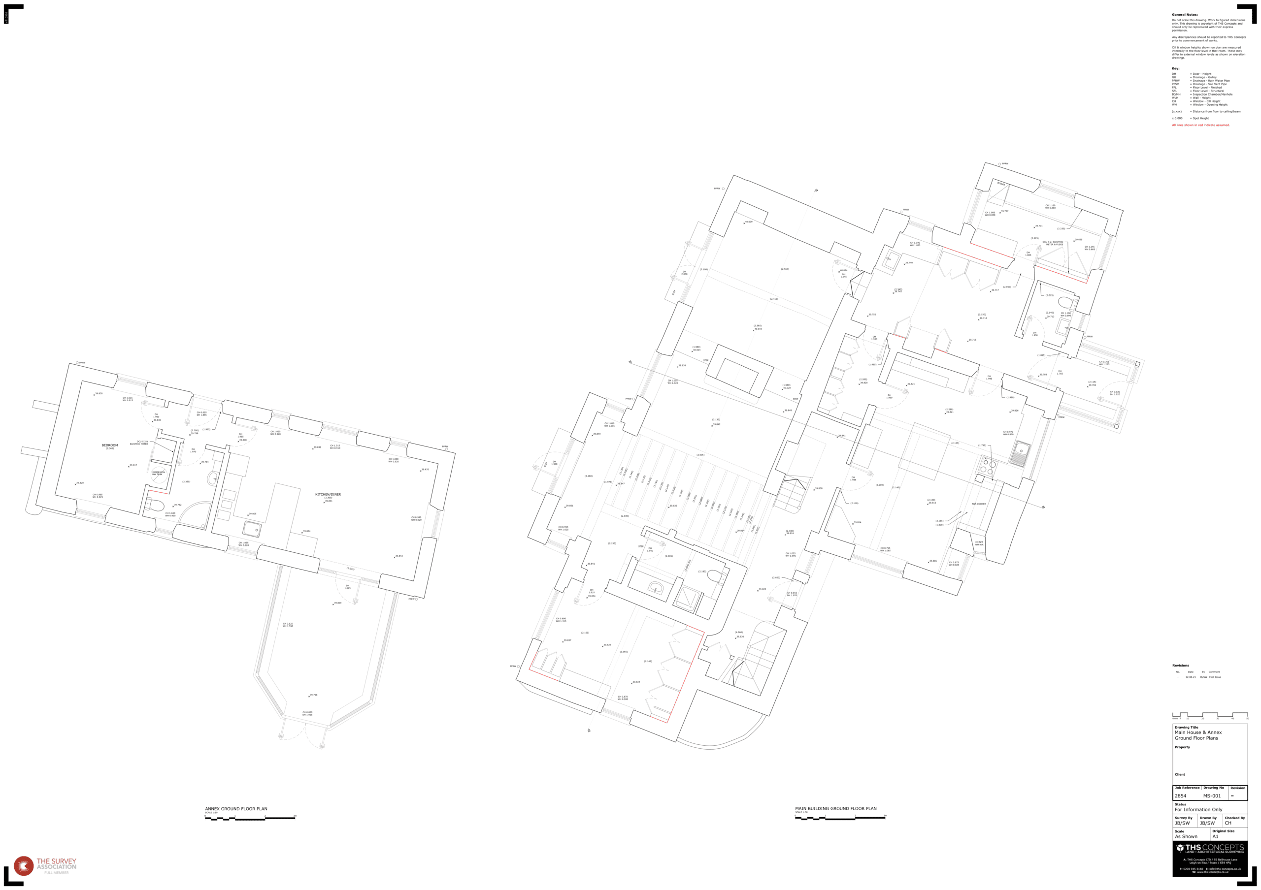
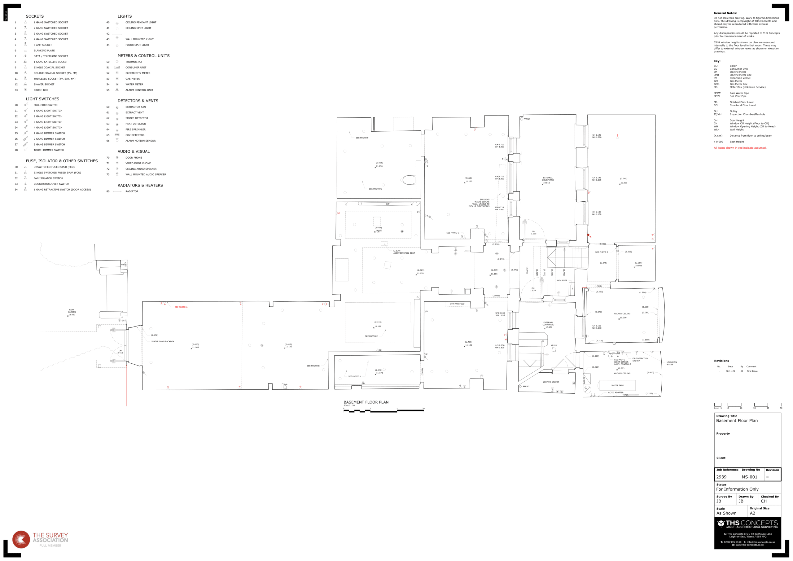
Floor Plans
We provide detailed top-down views of each property floor, cut at 1m above floor level.
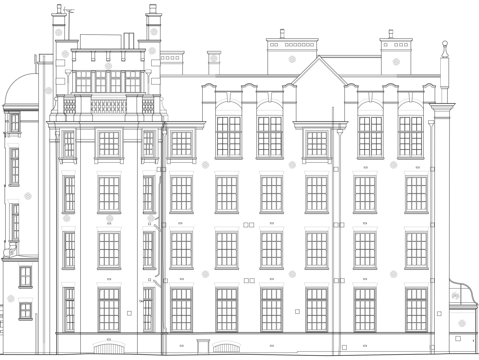
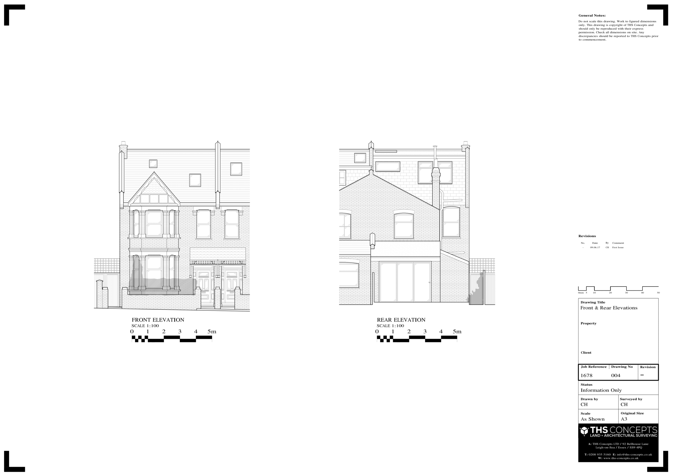
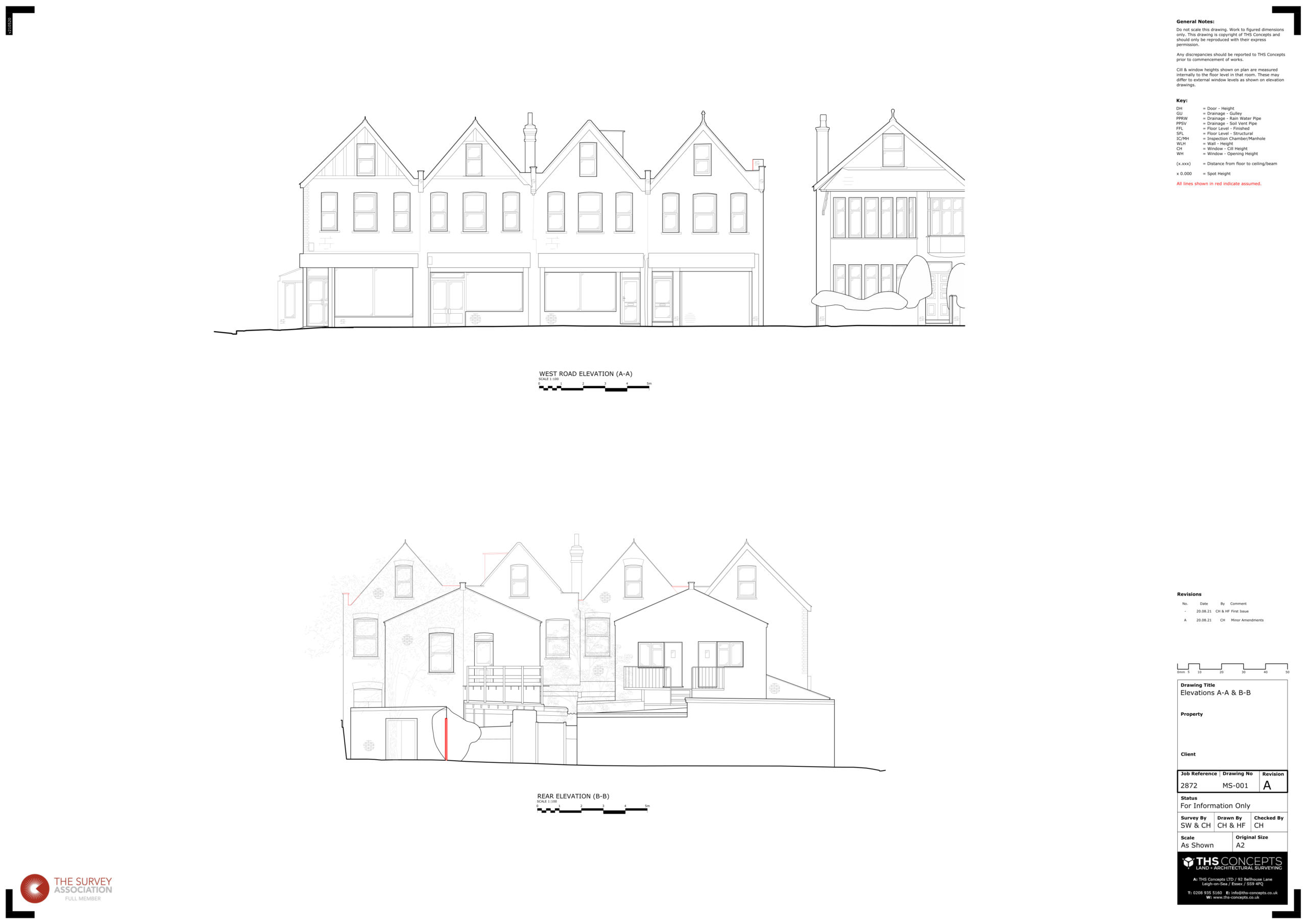
Elevations
High-detail elevation drawings created from 3D laser scan data of your building.
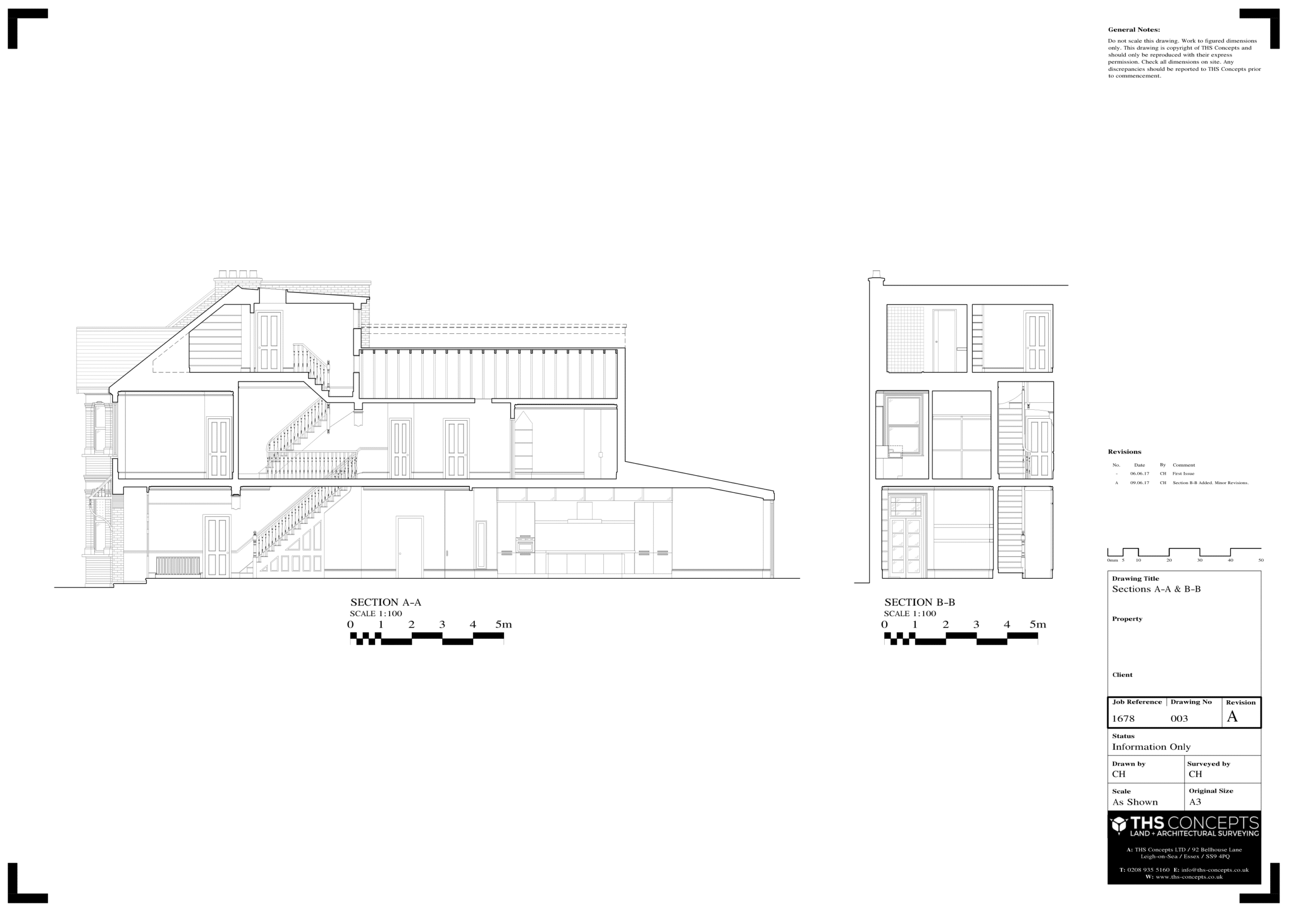
Sections
Detailed section cuts through your property, using internal and external 3D data.
Roof Plan
Accurate roof plans crafted using external and internal measurements for your building.
Site Plan
Detailed land and surrounding feature measurements, including fences and trees.
Loft Plan
Obtain detailed loft plans to facilitate your attic conversion projects with precision.
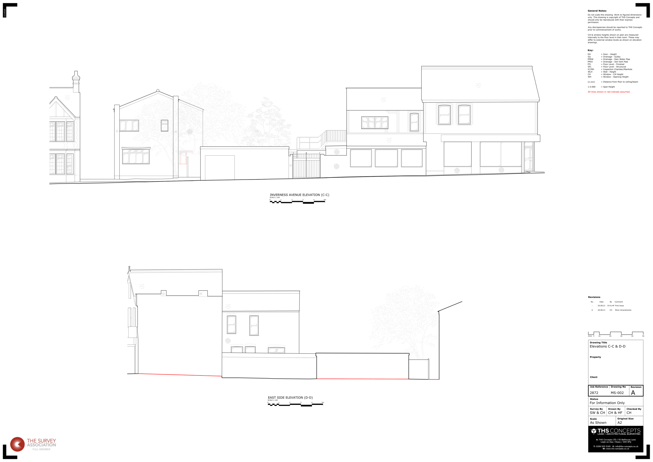
Street Scene Elevations
Detailed neighbouring property elevations from non-intrusive 3D scans.
Point Cloud File
Receive registered 3D point cloud data in LAZ/RCP format from us, free of charge.
Site Photographs
Access high-resolution on-site photos, aiding your design work with detailed visuals.
We Work With Architects, Designers & Engineers
At THS Concepts , we specialise in precise, comprehensive measured surveys for a variety of projects, from intimate residential properties to expansive commercial developments.
Our experienced team is equipped with the latest technology to deliver accurate results for any project, large or small. We pride ourselves on our meticulous attention to detail and commitment to quality.
Places We Have Worked
- Boston Flood Barrier
- Bradwell Nuclear Power Station
- Colchester Zoo
- Dover Port
- Hyde Park
- London City Airport
- London Underground Stations
- McClaren F1 Team HQ
- Port Of Monrovia (Liberia)
- Southend Pier
- Waterloo Railway Station
- Wembley Stadium
- West Ham / Olympic Stadium
- Whitehall (UK Government)
- Brighton Hospital
Precision Surveys Using 3D Laser Scanning Technology
THS Concepts employs state-of-the-art 3D laser scanning technology to capture every intricate detail of your building with both speed and precision.
Before commencing any survey, we engage in a detailed consultation with our clients to ascertain their specific project requirements. Given that each project often necessitates varying levels of detail in distinct areas, our approach is tailored to meet these unique needs.
Our survey service is designed to capture a diverse range of elements, depending on your specific requirements.
For more complex assignments, we extend our survey to include additional elements such as radiators, electrical outlets, lighting positions, and more.
If you require further guidance on what to include in your survey, RICS offers a comprehensive document titled ‘Measured Surveys of Land, Buildings and Utilities

Our Measured Survey Service In Detail
On-Site Survey
Our seasoned site survey team will visit your property to conduct a comprehensive 3D scan, capturing all the necessary measurements to create your precise drawings.
You have the option to provide us with your exact specifications, or you can rely on our expertise, honed from completing hundreds of measured survey projects over the years, to recommend the best approach for you.
CAD Drawings & PDF's
We utilise Autodesk’s industry-leading AutoCAD software to craft your CAD floor plans, sections, elevations and more.
Over the years, we’ve fine-tuned our drawing package to maximise efficiency, enabling our clients to seamlessly integrate, manipulate, and expedite their design projects.
Key Features Of Our Drawings:
- Through the use of layers, we organise the drawing meticulously, incorporating helpful colour coding, line types, and line weights for ease of use.
- We avoid cluttering the drawings with extraneous information, making them more straightforward and easier to comprehend.
- Upon request, we can align the drawings to Ordnance Survey grids, simplifying the integration of additional mapping data.
- Each drawing undergoes rigorous quality checks before dispatch to eliminate any elements that could lead to confusion.
- We provide scaled PDF copies, facilitating printing and markup for those who may not have access to AutoCAD.
For more information on CAD standards, you may refer to CAD Standards.
Point Cloud File
Upon completion of your measured survey or 3D laser scan, we offer you a link along with complimentary software to access the point cloud file of your building.
A point cloud enables you to navigate through your building in a virtual environment. You can take measurements, add markups, and experience your building as a 3D visualisation right on your computer!
For more information on how to utilise point cloud data, you may refer to Autodesk’s Point Cloud Software.
On-Site Photographs
During our visit to your property, we capture a series of photographs to assist us in the CAD drawing process. These images not only facilitate our work but can also be invaluable to you.
We offer to share this photo folder with you, which could serve multiple purposes. It can be a useful resource for future reference or even act as a compelling before-and-after record of your property.
For tips on how to effectively use photographs in your design projects, you may refer to this ArchDaily article.
Aftercare & Guarantee
We ensure you are 100% happy with the measured survey drawings we provide. If there are any issues, then we are more than happy to rectify these free of charge. This may include re-visiting the site or addressing something in the drawings.
In the event that you are still not satisfied with our services, we offer a 100% money-back guarantee.
See Some Measured Survey CAD & PDF Examples
THS Concepts offers a diverse range of CAD drawing services, spanning both 2D and 3D formats. Whether you require straightforward 2D floor plans or intricate BIM Revit Models, we have you covered.
Explore some of our Example DWG CAD Files to get an idea of the quality and variety we offer.
We can tailor our services to provide various types of CAD drawings to meet the specific needs of your project.
Floor Plans
A floor plan is a two-dimensional layout of a room or building, showing the relationships between rooms, spaces, and other physical features at one level of the structure.
It typically includes dimensions and labels for doors, windows, walls, and fixed objects, as well as furniture and appliances.
Roof Plans
A roof plan is a specialised architectural drawing that provides an overhead view of a building’s roof structure. It typically includes details such as the roof’s pitch, material, and features like chimneys and vents, as well as drainage systems.
Loft Plans
A loft plan is a detailed architectural drawing that focuses on the layout and features of a loft space within a building. It often includes dimensions, structural elements, and any specific design features like skylights or storage areas. Loft plans are particularly useful for conversions or renovations.
Site Plans
A site plan provides an aerial view of the entire property, including the building, landscaping, and any external features like driveways or garden paths. It’s essential for understanding the layout of the property, and is often required for planning permission.
Street Scene Elevations
These drawings provide a view of how the building will look from the street level, often in the context of neighbouring buildings. They are particularly important for understanding the visual impact of a new building or renovation on its surrounding environment.
Internal Wall Elevations
These are vertical drawings that show the details of internal walls within a building. They can include the placement of windows, doors, built-in features, and sometimes even furniture. These drawings are crucial for interior design and renovation projects.
Measured Survey Pricing & Quotes
Typical Costs
Each building and project presents its own unique set of challenges, making it difficult to offer a one-size-fits-all pricing structure for measured surveys.
To address this, we’ve compiled a comprehensive guide that outlines typical costs associated with measured surveys and offers insights on how to optimise your budget.
How To Get a Quote
Getting a quote is straightforward. Simply contact us and provide your address along with the specific drawings you need.
We’ll promptly respond with a complimentary, no-obligation quote within one working day. You can also get an instant measured survey estimate using our free, online tool.
Payment Terms
We offer very generous payment terms and only invoice once the drawing and on-site work has been completed.
We send you a PDF proof of our work and then ask for the invoice to be paid prior to releasing the CAD files.
Frequently Asked Questions
A measured building survey is a thorough and precise examination of a building’s size, features, and overall condition. This process typically requires a surveyor to visit the building and use specialized tools like lasers or total stations to gather detailed information about the building’s layout, features, and state.
Based on the data collected, the surveyor will create detailed plans and drawings, including floor plans, elevations, sections, and other views of the building.
Measured building surveys are conducted for a variety of reasons, including designing renovations or extensions, obtaining building regulations / planning applications, or simply gaining a better understanding of the building’s layout and condition.
For a more comprehensive guide to measured building surveys, please refer to our detailed article here.
The cost of a measured building survey depends on a number of factors such as the size of the property, the location and the level of detail required. A typical cost for the average architect’s requirements on a 3-bedroom house will be between £1000 and £2000.
We have written an article on how much you can expect to pay for a measured survey.
A measured building survey is a critical step for architects, engineers, and construction professionals to begin their projects accurately. By precisely surveying the required area and producing accurate CAD drawings, the survey forms the basis of the design proposals. Without a quality survey, design and build issues may arise.
This type of survey is detailed and involves taking precise measurements of a building’s dimensions, including the size, location, and shape of all features and components. A measured dimensional survey offers several benefits, such as providing accurate and detailed plans of a building’s layout and features for purposes like designing renovations or extensions, preparing building regulations applications, or simply understanding the layout of a building.
Moreover, a measured dimensional survey can be instrumental in planning construction projects, meeting legal requirements or lender requirements for mortgage applications, or determining a property’s value by providing a detailed and accurate assessment of its features and dimensions.
In summary, a measured dimensional survey is an indispensable tool for anyone seeking to understand a building’s dimensions and layout, especially for those planning renovations, extensions, or other building work.
We undertake measured building surveys in the counties surrounding our offices. These include:
- London
- Essex
- Kent
- Hertfordshire
- Sussex
- Surrey
- Buckinghamshire
However, we have been much further afield within the UK and internationally. We have undertaken surveying work as far away as Liberia in West Africa.
If you would like a quote for a project, then please get in touch.
To measure a building, we use a range of high-tech equipment. The primary piece of equipment is a 3D laser scanning device which scans over 100,000 points per second. The 3D scanner surveys an extremely detailed picture of a building, allowing us to present the drawings in a very accurate, precise and detailed manner.
We use a range of other equipment depending on the complexity of the job. From the more complex total stations and GPS equipment to laser measures and measuring tapes.
When in the office we use a variety of software packages to process the information. For our point cloud data we use a program called Faro Scene which helps clean up and register point cloud files together. We use Autodesk AutoCAD for our CAD work.
This obviously depends on the size and the scope of the project. Typically, we will be able to get to your site within 10 days and drawings are usually issued within 7 days of the final day on site.
Absolutely, we can liaise with your design team directly or even discuss what you may require for your project. We have undertaken 100’s of measured survey projects so know what is usually required depending on what you are looking to build.
Yes. The land around your building is often very important when planning a project. We can undertake topographical land surveys to pick up all the detail you require.
Our measured building surveyors provide you with accurate, easy to manipulate measured building survey information to help you design your projects more effectively. You can rely on the information we provide, which is undertaken to RICS (Royal Institute Of Chartered Surveyors) standards.
Our clients receive great service from us, which is reflected in our 5 star reviews on Google and Trustpilot. We ensure you are happy before, during and well after the project has ended.
As a professional surveying company, we carry all the relevant insurance to give our clients confidence in what we produce. We offer a money-back guarantee on all our work and have £5 million in both professional and public liability insurance.
Measured Surveys - Case Studies


Useful, Free Guides


Other Useful Services
Other services may be available in addition to our measured survey service to assist you with your project. Please see below:
Our land surveyors measure the land around your building, picking up key bits of information such as land heights, tree locations, outbuildings, changes in surface, drainage, and more.
See our topographical survey service
We can scan the ground underneath your property to detect and mark utilities such as electricity, gas and water pipes.
See our utility scanning service.
From the air, we can take high resolution photos of your property to help showcase as well as spot potential issues around the building.
See our drone photograph services.