3D Scanning – France – Morzine
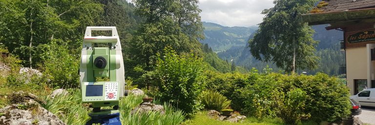
Detailed 3D laser scanning and total station surveying of a hotel and chalet in Morzine, The Alps, by THS Concepts.
Limited Time Offer: Enjoy 10% Off All Services
Get a quote now – this discount won’t last long!
Operating across London and the UK, we engage with architects and engineers on architectural, heritage, and structural projects, capturing their buildings and structures in 3D, then creating a series of as-built CAD drawings / models.
Are you aware of your specific needs and/or wish to include files? Please complete our detailed form here.
THS Concepts are an accredited member of The Survey Association body.
We operate nationwide across the United Kingdom.
THS Concepts was formed over 10 years ago in 2013.
£1 million in liability cover, employers' and public liability insurance.
We take great pride in our exceptional 5-star ratings on both Google and Trustpilot
At THS Concepts, we specialise in delivering exceptional 3D laser scanning services across London and the South East. Our team of experienced professionals utilises cutting-edge 3D scanner technology to capture and document highly accurate and detailed point cloud data. This data is invaluable for a wide range of architectural, heritage and structural applications.
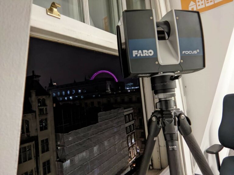
With the utilisation of state-of-the-art FARO 3D scanners, we cater to various applications and projects. Our expertise extends to scanning for construction and engineering purposes, encompassing diverse sites and applications. The point clouds and drawings we produce empower our clients to design with utmost confidence, knowing they have precise and reliable data at their disposal.
In addition to our comprehensive 3D laser scanning service, we also offer a range of services to meet our clients’ diverse needs. These services include measured building surveys, topographical surveys, setting out services, and more. Our aim is to provide a holistic solution that covers all aspects of surveying and data acquisition, ensuring our clients have access to a complete suite of services to support their projects.
With a commitment to excellence and a focus on delivering superior results, THS Concepts is the trusted partner for your 3D scanning and surveying requirements in London and the South East. Contact us today to discuss your project and discover how our expertise can add value to your endeavours.

2 - Book in your survey date. We work around your schedules and requests.
3 - On-site measured survey work undertaken by our survey team using 3D laser scanners.
4 - Office work to draw and produce CAD drawings & point cloud file.
5- We then send the CAD, PDF, photos, and point cloud file to our client.
3D scanning in architecture and building projects offers unmatched precision, transforming design and documentation processes. This technology captures detailed measurements, creating accurate digital models that reduce errors compared to traditional surveying. It enables precise planning, enhances problem anticipation, and optimises construction, ensuring every detail is accurately captured for informed decision-making.
Producing precision drawings and models from 3D scans is crucial for historical preservation, retrofitting, and integrating new designs with existing buildings. It promotes collaborative and adaptive design, allowing for efficient material use and reduced over costs. Embracing 3D scanning marks a shift towards innovative and efficient construction, establishing new industry standards for accuracy and excellence.
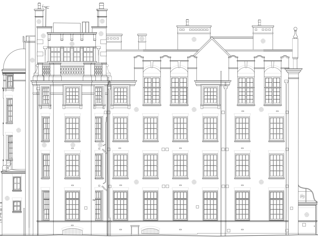
Utilising our fleet of Faro 3D scanners and Leica total stations we accurately survey existing buildings and structures and produce 2D and 3D CAD data. We usually work with Architects on refurbishment projects looking to get accurate drawings such as floor plans, sections, and elevations.
We have scanned a number of high-profile buildings across the United Kingdom. These include:
Repairs and alterations
Using our calibrated Faro 3D scanners, we can produce feature-rich point clouds of the hull and internal areas of your vessel. Utilising point cloud data will assist in designing and manufacturing components to perfectly fit where they need to go.
We have been involved in several projects ranging in size and complexity. These include:
Using point cloud data of your vessel, we can accurately produce as-built drawings showing elevations, sections, and plans. We produce lines plans drawings taking sections through the hull at set intervals as well as verification of C Marks & Draught marks. We can check if these critical marks are accurate and set correctly in comparison to the underside of the keel/deck lines.
Historical/Heritage Vessels
3D laser scanning is a great method to capture historical vessels without the need to physically touch or measure the vessel. The colourised point cloud can be used to capture the boat and produce an electronic record for future alterations, repairs, and rebuilds.
Measurements for Yachts
We can accurately record the shape of a yacht’s hull (when dry-docked) to produce accurate plans, elevations, and sections. This can be useful for applications such as yacht racing where precise measurements are required for race verification.
3D laser scanning is an efficient and accurate method of capturing the physical dimensions and shape of existing infrastructure, such as roads, bridges, and buildings. By emitting a laser beam and capturing the reflections off the surface of the object, the scanner is able to create a detailed, 3D model of the object.
This process can be used to create accurate maps and models of existing infrastructure, which can be helpful in a variety of ways. For example, if a new construction project is planned in an area with existing infrastructure, the 3D model can be used to understand the layout and condition of the existing infrastructure and plan the new project accordingly. Similarly, if an existing piece of infrastructure, such as a bridge, needs to be repaired or maintained, the 3D model can be used to understand the exact dimensions and features of the structure and plan the work accordingly.
Overall, 3D laser scanning can be a valuable tool in the planning, design, and maintenance of infrastructure projects, as it allows for the creation of accurate, detailed models that can be used for a variety of purposes.
3D laser scanning is a process of capturing the physical dimensions and shape of an object or environment using a laser beam. The scanner emits a laser beam, which reflects off the surface of the object and is captured by the scanner. This process is repeated many times, and the data collected is used to create a 3D model of the object or environment.
3D laser scanning has a number of applications, including surveying and mapping, architecture and construction, product design and engineering, and cultural heritage preservation. It is known for its high level of accuracy and speed, and it can be used to capture detailed, 3D models of objects and environments that would be difficult or impossible to measure using traditional methods.
The point cloud data can be viewed on a computer and used to create a variety of 2D and 3D drawings, such as floor plans, elevations, and sections. 3D laser scanners are known for their accuracy and speed, as they can survey hundreds of thousands of points per second and capture complex spaces quickly. They are also useful for surveying inaccessible areas, such as the underside of bridges or building facades.
3D laser scanners use lasers to create a 3D digital model of an object or environment. They work by emitting a laser beam and measuring the time it takes for the beam to bounce back after it hits an object. By measuring the time it takes for the beam to bounce back, the 3D laser scanner can determine the distance to the object and create a 3D model of it.
There are several different types of 3D laser scanners, including time-of-flight scanners, phase-shift scanners, and triangulation scanners. Time-of-flight scanners measure the time it takes for the laser beam to travel from the scanner to the object and back again. Phase-shift scanners measure the phase shift of the laser beam as it reflects off the object. Triangulation scanners use a laser and a camera to measure the angle and distance to the object.
3D laser scanners can be used for a variety of applications, including surveying, mapping, inspection, and reverse engineering. They are often used in manufacturing, construction, and other industries where accurate measurements and detailed 3D models are required.
The price of a 3D laser scan depends on the size and complexity of your property. Important factors that increase or decrease 3D laser survey costs include the survey area, the detail you require, and the quality of the companies undertaking the survey.
Typically, most surveying companies charge between £300 and £1000 for a day’s work on site. To follow on from the survey, time is required in the office to draw everything up. A day’s drawing in the office may be charged at £200 to £500 a day. Don’t forget to factor in VAT!
At THS Concepts, we prefer to give a one-off price for both the surveying and drawing work. That way, our clients know exactly what they are going to get and for how much.
There are several benefits to using 3D laser scanning, including:
Accuracy: 3D laser scanning is highly accurate and can capture details down to millimeter or even sub-millimeter levels. This makes it ideal for capturing the precise dimensions and geometry of an object or environment.
Speed: 3D laser scanning can capture large amounts of data very quickly, making it a fast and efficient method for capturing complex shapes and surfaces.
Non-contact: 3D laser scanning is a non-contact method, which means it does not require physical contact with the object or environment being scanned. This makes it ideal for scanning fragile or delicate objects, as well as objects that are difficult to access.
Versatility: 3D laser scanning can be used to scan a wide variety of objects and environments, including buildings, landscapes, sculptures, and even people.
3D laser scanning is a process that uses lasers to measure the physical properties of objects and environments in three dimensions. The data collected through laser scanning can be used to create 3D models and computer-aided design (CAD) drawings of the scanned objects or environments.
There are several steps involved in the process of converting 3D laser scan data into a CAD model:
Data collection: The first step is to collect the 3D laser scan data using a laser scanner. The scanner sends out laser beams and measures the distance between the scanner and the objects being scanned.
Data processing: Once the data has been collected, it must be processed to create a usable 3D model. This typically involves aligning and merging multiple scans, and cleaning up the data to remove any errors or inaccuracies.
CAD modeling: The processed 3D scan data can then be used to create a CAD model of the scanned objects or environment. This is typically done using specialized software that allows the user to manipulate the 3D data and create a detailed, accurate model.
Finalization: The final step is to finalize the CAD model, which may involve adding additional details or features, and ensuring that the model is accurate and ready for use in the desired application.
Overall, the process of converting 3D laser scan data into a CAD model requires a combination of specialized equipment, software, and expertise to ensure that the resulting model is accurate and useful.
Measured Building Surveys
Laser scanning a building is a quick way to capture precise and accurate detail for your project. The data captured can be transferred into a BIM program such as Revit for further design and analysis.
Heritage Documentation
Capturing 3D data of heritage buildings is an excellent, non-intrusive way to pick up every nook and cranny. A 3D scan can pick up intricate detail that wouldn’t be possible using conventional surveying methods.
As-Built Verification Surveys
3D laser scanning is a reliable, accurate and quick way of capturing complex environments with features such as complex piping and ducting, enclosed spaces, inaccessible areas.
Topographical Surveys
Capturing land and building features via 3D scanning and the subsequent point cloud can help massively when designing complex schemes. The data provided can be instrumental in making a design work.
Street Scene Elevations
3D laser scanning provides exceptional elevation detail on buildings. A 3D laser scan can pick up intricate details that would be impossible to pick up using less advanced technology.
Infrastructure: Railways, Highways, Etc.
Scanning busy environments with complex access issues can be a headache in terms of safety, cost and time. Utilising 3D laser scanning for complex infrastructure projects allows you to quickly and safely capture vital data.
1 – Get A Quote
Speak to us today about your 3D laser scanning requirements. We then get a fixed price quote back to you for the scanning and any required drawing works. We also give you an indication of when we can start and when you can expect your data back!
2 – Site Survey
Our experienced laser scanning team will visit your property and undertake a 3D laser survey. We work to your specifications or suggest our own based on previous jobs.
3 – Drawing / Data
Following your survey, you will then receive your requested CAD model. This can be in a 2D or 3D format. We typically export drawings in either 2D or 3D CAD format of your choice. We can also issue you the point cloud file in a format of your choosing.
Our surveyor(s) takes plenty of photos on site, which are often useful during your project. We can send these in an easy-to-download OneDrive Link.
4 – After Care
We ensure you are 100% satisfied with the drawings and service we provide. Updates and amendments are no problem and are undertaken quickly to get your project moving.
We offer a range of different data and drawing types depending on your requirements. These include:
• BIM Models (Revit)
• DWG Files (AutoCAD)
• Elevations
• Sections
• Floor Plans
3D laser scanners and lidar (Light Detection and Ranging) systems are both technologies that use lasers to measure the distance between the sensor and objects in the environment. However, there are some key differences between the two technologies:
Purpose: 3D laser scanners are typically used to create detailed 3D models of objects and environments, while lidar systems are primarily used for autonomous navigation and mapping.
Scanning method: 3D laser scanners use a single laser beam to scan an object or environment, while lidar systems use multiple lasers that sweep across the field of view. This allows lidar systems to create a more detailed and accurate map of the environment.
Range: Lidar systems have a longer range than 3D laser scanners, which allows them to gather data from a greater distance.
Resolution: 3D laser scanners tend to have a higher resolution than lidar systems, which means that they can create more detailed and accurate models of objects and environments.
Overall, 3D laser scanners and lidar systems are both useful tools for measuring and mapping objects and environments, but they are used for different purposes and have different capabilities.
We can survey the land around your building, picking up key bits of information such as land heights, tree locations, outbuildings, changes in surface, drainage, and more.
See our topographical survey service
By default, we utilise 3D scanners on our measured survey projects to produce accurate 3D point cloud files. These are then translated into floor plans, elevations and sections etc.
See our utility scanning service.

Detailed 3D laser scanning and total station surveying of a hotel and chalet in Morzine, The Alps, by THS Concepts.

Comprehensive survey of a large government building overlooking 10 Downing Street.
To get started, please fill out our form below. After we check your project details we’ll send you a fixed price quotation within 24 hours illustrating costs and timelines to get everything returned to you.
Don’t fancy filling out the form? Get in touch via email or telephone:
Email: info@ths-concepts.co.uk
Call: 020 8935 5160
“Proactive on site and quick. Customer service is of the highest level as well. Will be using for all future projects.”
Are you aware of your specific needs and/or wish to include files? Please complete our detailed form here.
92 Bellhouse Lane, Leigh-on-Sea, Southend-On-Sea, Essex, SS9 4PQ
76 Quill Street, Finsbury Park, London, N4 2AD
THS Concepts has a passionate team of surveyors and CAD draughtsman delivering detailed, thorough and accurate surveys and CAD drawings. We are far more than just a land and building surveying company.
Terms & Conditions | XML Sitemap | Copyright 2022 – THS Concepts LTD